

Winslow has many activities in the historic downtown area and its location on the scenic Colorado Plateau >means easy access to some spectacular destinations.
Within Walking Distance
These great attractions are all located in historic downtown Winslow and within walking distance of La Posada. A Brief History of Winslow, Arizona, a short film created by the Old Trails Museum, provides an overview of Winslow’s history and information on many of the historic sites and buildings listed here.
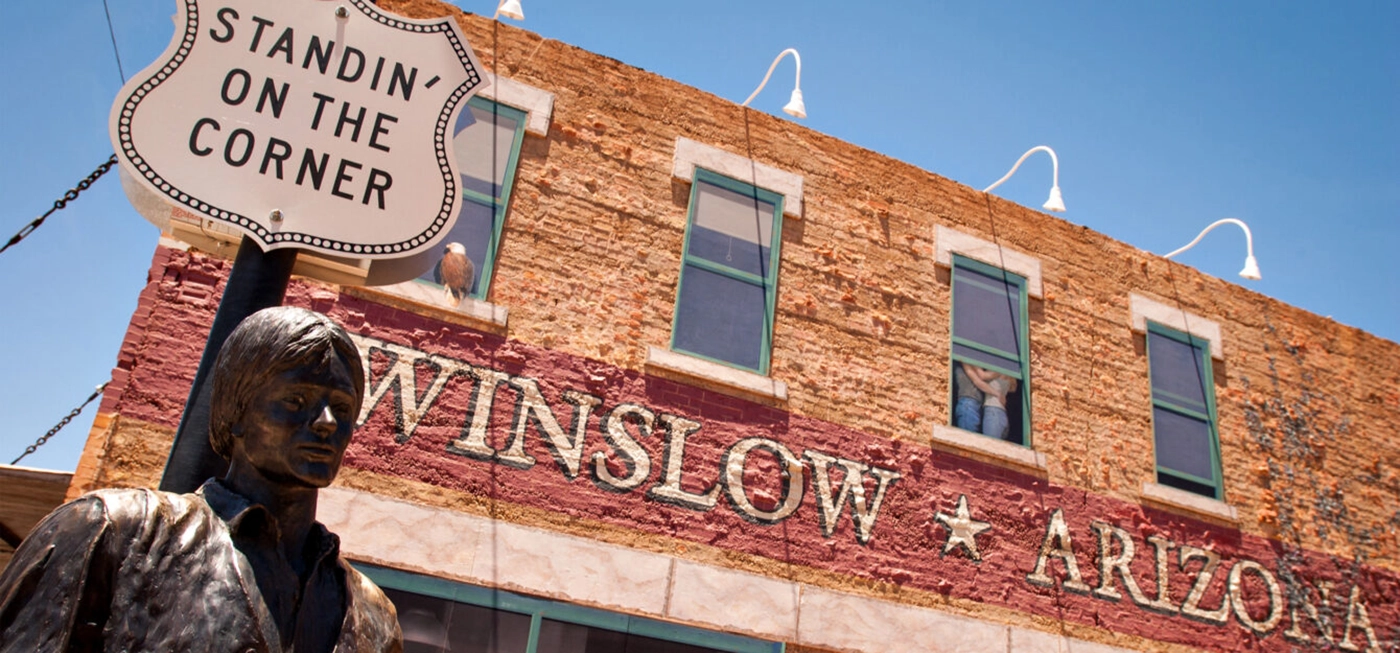
Standin’ on the Corner Park
standinonthecorner.com
Located in downtown Winslow on the northwest corner of Kinsley and Second streets, this park pays homage to the Jackson Brown’s 1970s hit Take it Easy, which was made famous by rock band The Eagles. It features a grand mural, bronze statue, and more.
Old Trails Museum
928.289.5861 | oldtrailsmuseum.org
The Old Trails Museum explores the history of Winslow — the Santa Fe Railway, Harvey Girls, Route 66, and much more — through free exhibits and public programs. Located two blocks west of the hotel and across from the Standin’ on the Corner Park, the museum is open Tuesdays through Saturdays from 11 am to 3 pm (check our website for holiday closures). The OTM Store specializes in Navajo and Hopi arts and books on local and regional history.
9-11 Remembrance Gardens
Located at the junction of Transcon Lane and Old Route 66 in east Winslow, this memorial (which is constructed of actual beams that came from the World Trade towers in New York City) pays homage to those who both lost their lives and assisted during the 9-11 tragedy.
Snowdrift Art Space
snowdriftart.com
Snowdrift Art Space is a gallery/studio/loft space on Historic Route 66 that features the work of sculptor Dan Lutzick. Snowdrift is located three blocks west of the hotel and in the former Babbitt Brothers department store, built in 1914. Free guided tours of Snowdrift are available by appointment only, and you can make a reservation (at least 24 hours in advance) by emailing us on the “Visit” page of our website.
Hubble Trading Post & First Street Pathway
The First Street Pathway links La Posada Hotel with another important historical site in downtown Winslow: the Hubbell Trading Post, now Winslow’s Visitor Center. Originally built by Hubert and C.D. Richardson in 1917, the trading post and warehouse was purchased by Lorenzo Hubbell in 1921.This spacious building became known as the home of the largest Navajo rug ever woven and the repository of the finest pawned specimens of old-time Navajo silver and turquoise jewelry. The Visitor Center is a must-see for the displays and literature on the local attractions.
Natural & Cultural Attractions
Winslow is near many ancient ruins and natural wonders; these all lie within 30 miles of town. If you’re willing to drive a bit farther, we recommend the Hubbell Trading Post.
Homolovi Ruins State Park
Distance: 3 miles
928.289.4106 | azstateparks.com/homolovi
This 4,000-acre park serves as a research center for the late migration period of the Hopi from the 1200s–1300s. It also provides the opportunity for visitors to see the sites and observe wildlife at an elevation of 4,900 feet. Facilities include a visitor center, museum, trails, a campground, and covered picnic tables. Take I-40 to Exit 257, then go 1.3 miles north on SR-87.
Rock Art Canyon Ranch
Distance: 13 miles
928.288.3260
Rock Art Ranch, situated in a remote area between Holbrook and Winslow, is home to one of the finest stands of Anasazi petroglyphs in the Southwest. It’s also a working cattle ranch that’s open from May through October. Small-group tours are given on Saturday afternoon at 1:00 p.m.; large-group tours must be arranged in advance for any weekday.
Canyon Diablo
Distance: 30 miles
theroadwanderer.net/railghosts.htm
This little-known ghost town is rumored to have been even rougher than Tombstone. A railroad bridge spans the canyon, once considered impassable by trains. There are plenty of ruins to explore, although you’ll need a 4WD vehicle to get there from 1-40 at Two Guns.
Brigham City
Distance: 5 miles
928.289.5901
Brigham City, the restoration site of a fort built by Mormon pioneers, was established in 1876. Although never attacked by Indians, this settlement on the Little Colorado only lasted 5 years because flash floods washed away dams and irrigation systems. The original walls of the fort were later moved to the grounds of La Posada. Brigham City is just off I-40, Exit 253; go west on North Road to La Prade Lane.
Outdoor destinations
Winslow’s location on the scenic Colorado Plateau means easy access to some spectacular destinations to hike, climb, boat and more. These are just a few.
Petrified Forest National Park
Distance: 55 Miles
928.524.6228 | nps.gov/pefo/index.htm
Best known for globally significant Late Triassic fossils, the park attracts many researchers. Geologists study the multi-hued Chinle Formation. Archeologists research over 13,000 years of history. Biologists explore one of the best remnants of native Arizona grassland. Air quality is an ongoing study in the park. Download the Friends of Petrified Forest National Park newsletter to learn more.
McHood Park/Clear Creek
Distance: 5 miles
928.289.5714
Outdoor enthusiasts will enjoy Clear Creek, which offers canoeing, fishing, swimming, and picnicking. Canoeist can paddle to Clear Creek Canyon — a deep, magnificent, secluded canyon. McHood Park is the perfect spot for camping and picnicking. From Winslow, take Route 87 south to Highway 99 and turn left.
Little Painted Desert County Park
Distance: 13 miles
928.524.4757
This park offers 660 acres of colorful formations of red, violet, green and gray, which were deposited by an ancient ocean and carved by the wind. View the panorama from the scenic overlook or use the picnic ramadas and restroom. Take Exit 257 from I-40; the park is located less than 1/4 mile from Highway 87, near the Navajo reservation.
Meteor Crater
Distance: 20 miles
928.289-2362 | meteorcrater.com
Meteor Crater is the best-preserved impact site on earth, with topographical terrain that closely resembles the surface of the moon. In fact, NASA designated the crater as the training site for astronauts. From Winslow, take I-40 west to exit 233.
Jack’s Canyon
Distance: 30 miles
For rock climbers, Jack’s Canyon features over 200 steep (5.5–5.13) routes concentrated in a section of the canyon called Moenkopi. All routes are well protected. Go south on Highway 87 to mile marker 313.7 and turn right, through gate (always close gate).

SNOWDRIFT ART SPACE

HOMOLOVI RUINS STATE PARK

CANYON DIABLO

PETRIFIED FOREST NATIONAL PARK

METEOR CRATER

JACK’S CANYON